
คู่มือเมือง
คู่มือเมือง
 เมือง
เมืองBangkok
Bangkok, officially known as Krung Thep Maha Nakhon and colloquially as Krung Thep, is the capital and most populous city of Thailand.
สำรวจ → เมือง
เมืองChiang Mai
Chiang Mai is the largest city in northern Thailand, the capital of Chiang Mai province and the second-largest city in Thailand by urban population.
สำรวจ → เกาะ
เกาะPhuket
Phuket is a city in the southeast of Phuket Island, Thailand, and the capital of Phuket province.
สำรวจ → จังหวัด
Krabi
Krabi is a province (changwat) of southern Thailand, on the shore of the Andaman Sea.
สำรวจ → เกาะ
เกาะKo Samui
Ko Samui or Koh Samui, often locally shortened to Samui, is an island off the east coast of Thailand.
สำรวจ → เมือง
เมืองPattaya
Pattaya is a city in Eastern Thailand, the second-largest city in Chonburi province and the eighth-largest city in Thailand.
สำรวจ → เมือง
เมืองAyutthaya
Phra Nakhon Si Ayutthaya, commonly known locally as Ayutthaya, is the capital of Phra Nakhon Si Ayutthaya province in Thailand.
สำรวจ → เมือง
เมืองHua Hin
Hua Hin is one of eight districts (amphoe) of Prachuap Khiri Khan province in the northern part of the Malay Peninsula in Thailand.
สำรวจ → เมือง
เมืองChiang Rai
Chiang Rai is the northernmost major city in Thailand, with a population of approximately 70,000 people.
สำรวจ → เมือง
เมืองPai
Pai is a small town in northern Thailand's Mae Hong Son Province, near the Myanmar border, about 146 km (91 mi) northwest of Chiang Mai.
สำรวจ →เกาะKo Phi Phi
The Phi Phi Islands are an island group in Thailand located in the Strait of Malacca between the large island of Phuket and the Straits coast in the Krabi Province.
สำรวจ → เกาะ
เกาะKo Tao
Ko Tao is an island in Thailand and is part of the Chumphon Archipelago on the western shore of the Gulf of Thailand.
สำรวจ →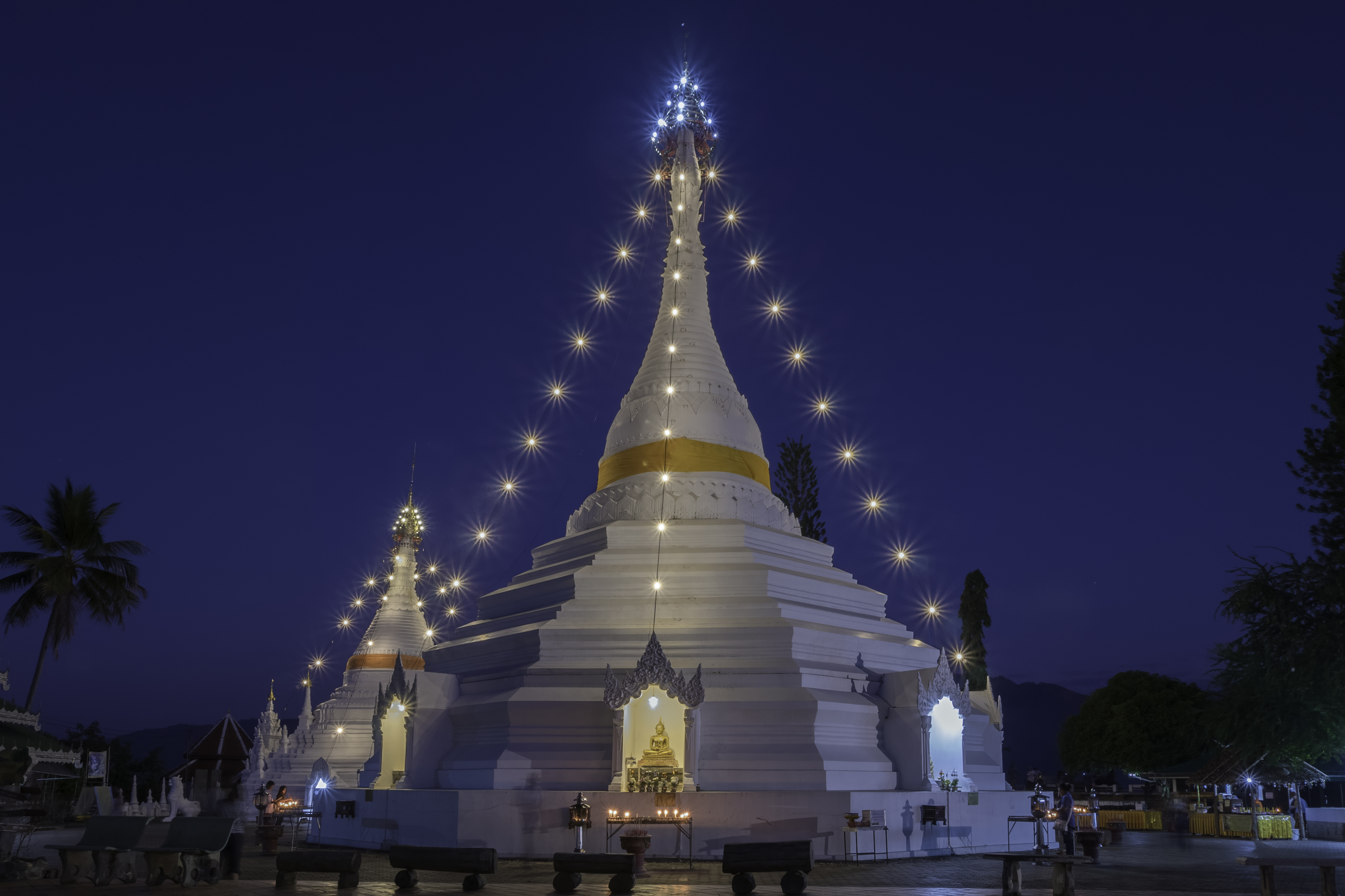 จังหวัด
Mae Hong Son
Mae Hong Son is Thailand's westernmost and most mountainous province, tucked into the Shan Hills along the Myanmar border and nicknamed 'the city of three mists.' With only 23 people per km², it has the lowest population density of any Thai province.
สำรวจ → จังหวัด
Lampang
Lampang is a large northern province set in the broad Wang River valley, historically part of the Lanna Kingdom and famous today as Thailand's last city where horse-drawn carriages still ferry passengers through the old town. Its 12,488 km² encompass nine national parks and some of northern Thailand's finest Lanna-era temple architecture.
สำรวจ → จังหวัด
Lamphun
Lamphun is the smallest province in northern Thailand, situated 26 km south of Chiang Mai in the Ping River valley, and is regarded as the heartland of the ancient Mon kingdom of Hariphunchai. Its golden chedi at Wat Phra That Hariphunchai, enshrining a hair relic of the Buddha, has drawn pilgrims since 897 CE.
สำรวจ →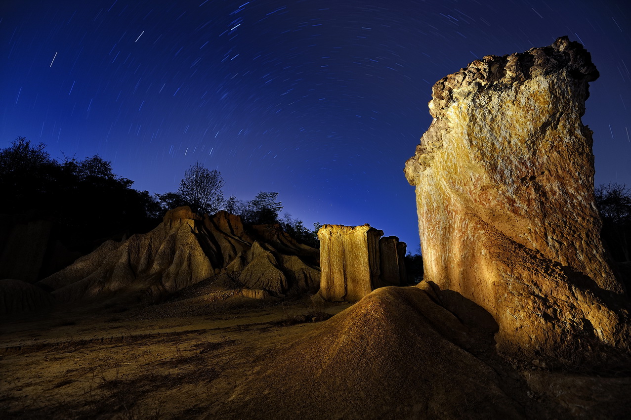 จังหวัด
Phrae
Phrae is a compact northern province in the Yom River valley known for its well-preserved teak mansions, centuries-old walled old town, and the striking eroded pillars of Phae Mueang Phi Forest Park — often called Thailand's Grand Canyon. The province has been a centre of indigo-dyed Mo Hom cotton weaving for generations.
สำรวจ → จังหวัด
Nan
Nan is a remote and scenically mountainous province in upper northern Thailand, its valley cradled by the Phlueng and Luang Prabang Ranges along the Laos border, and watered by the headwaters of the Nan River. Long an independent kingdom with its own distinct artistic tradition, Nan was designated a UNESCO Creative City of Crafts and Folk Art in 2025.
สำรวจ → จังหวัด
Phayao
Phayao is a tranquil northern province defined by Kwan Phayao, the largest freshwater lake in northern Thailand and the fourth largest in the country, whose calm waters mirror the mountains and the silhouette of the submerged Wat Tilok Aram. The provincial capital sits on the lake's eastern shore, flanked by three peaks exceeding 1,300 metres.
สำรวจ → จังหวัด
Uttaradit
Uttaradit — whose name means 'port of the north' — is a riverside province straddling the Nan River valley in upper northern Thailand, historically a key trade gateway between the Lanna highlands and the central plains. It is home to the Queen Sirikit Dam and the world's largest surviving teak tree, estimated at over 1,500 years old.
สำรวจ → จังหวัด
Chiang Rai Province
Chiang Rai is Thailand's northernmost province, founded in 1262 by King Mangrai as the first capital of the Lanna Kingdom, and today anchors a dramatic landscape where the borders of Thailand, Laos, and Myanmar converge at the Golden Triangle. The province spans 11,503 km² and is home to 1.3 million people, including substantial hill-tribe communities.
สำรวจ → จังหวัด
Tak
Tak is a large, predominantly forested province in western Thailand, bordering Myanmar along the Dawna and Tenasserim mountain ranges. It is home to Thi Lo Su, considered the largest waterfall in Thailand, and the Bhumibol Dam on the Ping River.
สำรวจ → จังหวัด
Sukhothai
Sukhothai province in lower northern Thailand is the cradle of the Thai nation, site of the 13th-century Sukhothai Kingdom traditionally regarded as the first Thai state. Its ancient capital and the satellite city of Si Satchanalai together form a UNESCO World Heritage Site.
สำรวจ →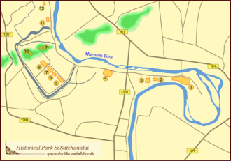 เมือง
เมืองSi Satchanalai
Si Satchanalai is a historic city in northern Sukhothai Province whose ruins form part of the UNESCO World Heritage-listed Historic Town of Sukhothai and Associated Historic Towns. Founded in 1250, it served as the residence of the crown prince during the height of the Sukhothai Kingdom.
สำรวจ →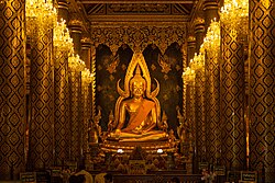 จังหวัด
Phitsanulok
Phitsanulok is a province in lower northern Thailand centred on the fertile plains of the Nan River, and is home to Phra Phuttha Chinnarat, one of the most revered Buddha images in Thailand. Covering 10,589 square kilometres, it sits at the geographic heart of the northern region.
สำรวจ → จังหวัด
Phichit
Phichit is a quiet agricultural province in lower northern Thailand, about 330 kilometres north of Bangkok, lying on the low fertile plains where the Nan and Yom Rivers converge. Rice and lotus are the predominant crops, and the province is virtually without significant forest cover.
สำรวจ →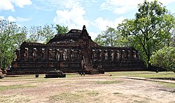 จังหวัด
Kamphaeng Phet
Kamphaeng Phet is a province in upper central Thailand with a rich history as a fortified royal city in the Sukhothai and Ayutthaya Kingdoms. Its ancient ruins, part of the UNESCO World Heritage Historic Town of Sukhothai and Associated Historic Towns, include impressively preserved temples and city walls.
สำรวจ → จังหวัด
Phetchabun
Phetchabun is a province in lower northern Thailand set in the broad valley of the Pa Sak River, flanked by parallel ridges of the Phetchabun Mountains to east and west. It is notable for Phu Thap Boek, its highest peak, and for the ancient Khmer-era ruins of Si Thep Historical Park.
สำรวจ → จังหวัด
Nakhon Sawan
Nakhon Sawan is a strategic province in lower northern Thailand at the confluence of the Ping and Nan Rivers, which merge here to form the Chao Phraya River. The province contains Bueng Boraphet, the largest natural freshwater lake in Thailand.
สำรวจ → จังหวัด
Uthai Thani
Uthai Thani is a province in lower northern Thailand stretching from the upper Chao Phraya River plains westward into forested mountains bordering Tak province. It is home to Huai Kha Kaeng Wildlife Sanctuary, a UNESCO World Heritage Site renowned for its biodiversity.
สำรวจ → จังหวัด
Chai Nat
Chai Nat is a small central Thai province on the flat alluvial plains of the Chao Phraya River valley, about 188 kilometres north of Bangkok. Its name means 'place of victory,' recalling its role as a successful military bulwark during the Ayutthaya period against Burmese invasions.
สำรวจ → จังหวัด
Sing Buri
Sing Buri is one of Thailand's smallest central provinces, situated on the flat Chao Phraya River plain between Nakhon Sawan and Ang Thong. It is celebrated for the heroic village of Bang Rachan, whose residents famously resisted Burmese forces in 1767 before the fall of Ayutthaya.
สำรวจ → จังหวัด
Ang Thong
Ang Thong is a small central Thai province in the Chao Phraya River basin, its name meaning 'gold basin' after the basin-like geography and the golden colour of its ripening rice. It is home to Wat Muang, which contains the tallest Buddha statue in Thailand.
สำรวจ → จังหวัด
Suphan Buri
Suphan Buri, meaning 'city of gold,' is a central Thai province on the fertile lower plains of the Tha Chin River, with a history of settlement stretching back over 3,000 years. It is best known for Don Chedi, the memorial marking King Naresuan's legendary elephant duel with the Burmese crown prince in 1593.
สำรวจ → จังหวัด
Kanchanaburi
Kanchanaburi is Thailand's third-largest province and lies in the west, bordering Myanmar along the Tenasserim Hills. It is world-famous for the Death Railway and Bridge on the River Kwai built by Allied POWs and Asian labourers during the Second World War, and for its extraordinary natural scenery.
สำรวจ → เมือง
เมืองKanchanaburi City
Kanchanaburi city is the provincial capital of Kanchanaburi Province, located approximately 120 kilometres west of Bangkok where the Khwae Noi and Khwae Yai Rivers converge into the Mae Klong River. It is the gateway to the Bridge on the River Kwai and the Thailand-Burma Death Railway, which are the town's defining landmarks.
สำรวจ → จังหวัด
Ratchaburi
Ratchaburi is a western central Thai province on the Mae Klong River plains, about 80 kilometres west of Bangkok, bordering Myanmar along the Tenasserim Hills. It is renowned for Damnoen Saduak Floating Market, one of the most photographed in Southeast Asia, and for the limestone cave temples of the Khao Ngu area.
สำรวจ →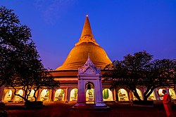 จังหวัด
Nakhon Pathom
Nakhon Pathom is often called Thailand's oldest city, with the Phra Pathom Chedi — the world's tallest Buddhist chedi at 127 metres — standing as evidence of Buddhism's ancient presence in the region. The province is 56 kilometres west of Bangkok in the flat Tha Chin River valley.
สำรวจ → จังหวัด
Samut Sakhon
Samut Sakhon is a small but densely populated coastal province at the mouth of the Tha Chin River on the Gulf of Thailand, forming part of the greater Bangkok metropolitan region. Its Mahachai seafood market is one of the largest fresh-fish trading centres in the country.
สำรวจ → จังหวัด
Samut Songkhram
Samut Songkhram is Thailand's smallest province by area, covering just 417 square kilometres on the Gulf of Thailand at the mouth of the Mae Klong River. It is known as the 'City of Three Waterways' for its intricate canal network and is famous for Amphawa Floating Market and riverside temple-hopping by boat.
สำรวจ → จังหวัด
Phetchaburi
Phetchaburi is a western coastal province at the northern end of the Malay Peninsula, bordered by the Gulf of Thailand to the east and Myanmar's Tenasserim Hills to the west. Kaeng Krachan National Park, covering nearly half the province, is Thailand's largest national park and a UNESCO World Heritage Site.
สำรวจ → จังหวัด
Prachuap Khiri Khan
Prachuap Khiri Khan is a long, narrow province on the Kra Isthmus in the upper Gulf of Thailand, where Thailand narrows to just 11 kilometres at its narrowest point. Beyond the Hua Hin resort area, it encompasses pristine fishing towns, limestone karst coastlines, and the military town of Prachuap Khiri Khan itself.
สำรวจ → จังหวัด
Saraburi
Saraburi is a central Thai province on the eastern side of the Chao Phraya valley, 108 kilometres north of Bangkok, serving as a gateway between the central plains and the northeastern plateau. It is home to Wat Phra Phutthabat, enshrining a revered footprint of the Buddha that draws pilgrims from across Thailand.
สำรวจ → จังหวัด
Lop Buri
Lop Buri is a historically rich province in central Thailand, known as Lavo during its long history as a Mon and later Khmer-influenced kingdom dating back at least to the 6th century CE. The ancient city of Lopburi — once a second capital of the Ayutthaya Kingdom under King Narai the Great — is famed for its Khmer-era temple ruins and its resident population of crab-eating macaque monkeys.
สำรวจ → จังหวัด
Phra Nakhon Si Ayutthaya Province
Phra Nakhon Si Ayutthaya province is a central Thai province covering 2,548 square kilometres in the flat Chao Phraya River valley, situated 76 kilometres north of Bangkok. Its ancient capital served as the seat of the Ayutthaya Kingdom for 417 years and is today a UNESCO World Heritage Site.
สำรวจ → จังหวัด
Nonthaburi Province
Nonthaburi is one of the smallest yet most densely populated provinces in Thailand, covering just 637 square kilometres immediately north and west of Bangkok along the Chao Phraya River. It forms an integral part of the Bangkok Metropolitan Region and is Thailand's second most densely populated province after the capital itself.
สำรวจ → จังหวัด
Pathum Thani Province
Pathum Thani, whose name means 'lotus flower town', is a central Thai province lying immediately north of Bangkok on the low alluvial flats of the Chao Phraya River. With a population of over 1.2 million and a density ranking fourth in the country, it is effectively an extension of the Bangkok metropolitan area.
สำรวจ → จังหวัด
Samut Prakan Province
Samut Prakan is a central Thai province at the mouth of the Chao Phraya River on the Gulf of Thailand, forming the southern gateway of the Bangkok Metropolitan Region. Known locally as Pak Nam (meaning 'river mouth'), it covers 947 square kilometres and is Thailand's third most densely populated province.
สำรวจ → จังหวัด
Nakhon Nayok Province
Nakhon Nayok is a small central Thai province about two hours east of Bangkok, celebrated for its mountain scenery, waterfalls, and proximity to Khao Yai National Park. The province covers 2,141 square kilometres and encompasses terrain ranging from forested highlands to a fertile central river plain.
สำรวจ → จังหวัด
Chachoengsao Province
Chachoengsao is an eastern Thai province covering 5,169 square kilometres whose name derives from a Chong word meaning 'deep canal', reflecting its landscape of waterways and river plains. The province straddles the Bang Pakong River basin and has a population of approximately 733,000.
สำรวจ → จังหวัด
Prachin Buri Province
Prachin Buri, whose name translates as 'City of the East', is an eastern Thai province covering 5,026 square kilometres between the Bang Pakong River valley and the forested plateaus of the Sankamphaeng Range. The province had a population of about 500,607 in 2024.
สำรวจ → จังหวัด
Sa Kaeo Province
Sa Kaeo is a frontier province in eastern Thailand, about 200 kilometres from Bangkok, sharing a long border with Cambodia's Banteay Meanchey and Battambang provinces. Created in 1993 from six districts of Prachinburi, it covers 6,831 square kilometres and had a population of approximately 562,000 in 2024.
สำรวจ → จังหวัด
Chon Buri
Chon Buri is an eastern Thailand province on the Bay of Bangkok, home to the resort city of Pattaya and Laem Chabang, Thailand's primary deep-sea port. The province is a cornerstone of the Eastern Economic Corridor, blending heavy industry with some of Thailand's most visited beaches.
สำรวจ → เกาะ
เกาะKo Si Chang
Ko Si Chang is a small island in the Gulf of Thailand, lying 12 km off the coast of Si Racha district in Chon Buri province. The island served as a royal retreat for three Chakri Dynasty kings and retains the partially restored Phra Chuthathut Palace as its chief attraction.
สำรวจ → เมือง
เมืองSi Racha
Si Racha is a coastal industrial city in Chon Buri province, situated on the eastern shore of the Gulf of Thailand approximately 120 km south-east of Bangkok. The city is internationally recognised as the birthplace of Sriracha hot sauce and is a key hub within Thailand's Eastern Seaboard industrial zone.
สำรวจ → จังหวัด
Rayong
Rayong is an eastern Thailand province bordering the Gulf of Thailand to the south, renowned for both its white-sand beaches and its pivotal role as the centre of Thailand's petrochemical and automotive industries. As of 2016, Rayong recorded the highest per-capita income of any Thai province.
สำรวจ → จังหวัด
Chanthaburi
Chanthaburi is an eastern Thailand province celebrated as one of the world's foremost gem-trading centres and Thailand's leading durian-producing region. Its provincial slogan — "Renowned waterfalls, town of fruit, good pepper, bountiful jewels" — captures its exceptional natural and commercial identity.
สำรวจ → จังหวัด
Trat
Trat is Thailand's easternmost province on the Gulf of Thailand, sharing a land border with Cambodia and encompassing the Ko Chang archipelago of over 50 islands. It is one of the wettest provinces in Thailand, receiving more than 4,500 mm of rainfall annually.
สำรวจ →เกาะKo Chang
Ko Chang is the third-largest island in Thailand by area, after Phuket and Ko Samui, covering approximately 210 km² in Trat province near the Cambodian border. The island is dominated by densely forested mountains, the highest of which, Khao Salak Phet, reaches 744 m, and is protected within Mu Ko Chang National Park.
สำรวจ → เกาะ
เกาะKo Kood
Ko Kood, also written Ko Kut, is the largest island in Trat province and the fourth-largest island in Thailand, situated in the Gulf of Thailand close to the Cambodian maritime border. The island is known for its pristine beaches, lush jungle waterfalls, and a conspicuous absence of mass tourism.
สำรวจ → เกาะ
เกาะKo Mak
Ko Mak is a small, largely flat island in eastern Trat province covering 16 km², making it the third-largest island in the province after Ko Chang and Ko Kood. Named after the areca (betel) nut, the island is celebrated for its long sandy beaches and peaceful, low-key atmosphere.
สำรวจ → จังหวัด
Nakhon Ratchasima
Nakhon Ratchasima, widely known as Korat, is the gateway province to northeastern Thailand (Isan) and the country's second largest province by area at 20,736 km². It sits at the western edge of the Khorat Plateau, approximately 259 kilometres northeast of Bangkok.
สำรวจ → เมือง
เมืองKorat (Nakhon Ratchasima City)
Korat — the common name for Nakhon Ratchasima city — is the largest city in northeastern Thailand and the third-largest in the country, with an urban population of approximately 466,000 as of 2021. It lies 250 kilometres northeast of Bangkok and serves as the commercial, transport, and cultural hub of Isan.
สำรวจ → จังหวัด
Buri Ram
Buri Ram province, whose name means 'city of happiness', lies in the lower Isan region at the southern end of the Khorat Plateau and covers 10,080 km². The province is renowned for its spectacular Khmer heritage, extinct volcanic landscape, and status as Thailand's foremost sporting province.
สำรวจ → จังหวัด
Surin
Surin province in lower northeastern Thailand covers 8,854 km² and is home to approximately 1.36 million people of diverse Khmer, Kuy, and Lao ethnicities. It is internationally famous for its domesticated elephants and for producing some of Thailand's finest silk.
สำรวจ → จังหวัด
Si Sa Ket
Si Sa Ket province occupies 8,936 km² in lower northeastern Thailand and is home to around 1.44 million people from four main ethnic groups — Kui, Lao, Khmer, and Yer. The province shares a long border with Cambodia and contains some of the most significant Khmer ruins found in Thailand.
สำรวจ → จังหวัด
Ubon Ratchathani
Ubon Ratchathani is Thailand's fifth-largest province by area at 15,626 km² and the third most populous with nearly 1.87 million residents, situated in the far southeast of Isan where the Mun River meets the Mekong at the border with Laos. Its name means 'royal lotus city', reflected in the lotus-flower provincial seal.
สำรวจ → เมือง
เมืองUbon Ratchathani City
Ubon Ratchathani city is one of the four major urban centres of Isan, located approximately 615 kilometres northeast of Bangkok on the Mun River near its confluence with the Mekong. It is best known for hosting Thailand's grandest Candle Festival each July, when elaborately carved wax sculptures are paraded through the city.
สำรวจ → จังหวัด
Yasothon
Yasothon is a small province of 4,131 km² in the centre of Isan, separated from Ubon Ratchathani in 1972, with a population of around 525,000. It is most celebrated as the home of Thailand's most spectacular Bun Bang Fai — the annual Rocket Festival held each May to invoke rain for the rice-planting season.
สำรวจ → จังหวัด
Amnat Charoen
Amnat Charoen is one of Thailand's four newest provinces, carved from Ubon Ratchathani on 12 January 1993, and covers just 3,290 km² in the Mekong valley of central Isan. With a population of around 372,000, it is among the least populous provinces in the region and is known locally as the 'Land of Dharma'.
สำรวจ →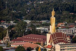 จังหวัด
Roi Et
Roi Et province in central Isan covers 7,873 km² on flat plains 130 to 160 metres above sea level, drained by the Chi, Yang, and Mun rivers, with a population of approximately 1.28 million. Its name, meaning 'one hundred and one', derives from the eleven ancient city gates built for the province's vassal states — a number that evolved through local tradition.
สำรวจ → จังหวัด
Maha Sarakham
Maha Sarakham province covers 5,607 km² of flat rice-growing plains in central northeastern Thailand, straddling the Chi River, with a population of approximately 930,000. Long regarded as the intellectual centre of Isan, it hosts Mahasarakham University, one of the largest universities in the northeast.
สำรวจ → จังหวัด
Kalasin
Kalasin province in upper northeastern Thailand spans 6,936 km² of hilly terrain separated from Sakon Nakhon by the Phu Phan mountain range, with a population of around 962,000. The province is internationally significant for Phu Kum Khao, the largest dinosaur fossil site in Thailand, and for its traditional silk-weaving heritage.
สำรวจ → จังหวัด
Chaiyaphum
Chaiyaphum province covers 12,698 km² at the western margin of Isan where the Khorat Plateau meets the Phetchabun mountain range, making it roughly half forested uplands and half agricultural plateau, with a population of approximately 1.1 million. It is distinguished by six national parks and wildlife sanctuaries, and by seasonal fields of Siam tulips that bloom across Pa Hin Ngam National Park each July and August.
สำรวจ → จังหวัด
Khon Kaen Province
Khon Kaen is a landlocked province at the heart of northeastern Thailand's Khorat Plateau, often regarded as the economic and educational capital of the Isan region. With a provincial population of approximately 1.8 million, it is one of the most populous and developed provinces in the northeast.
สำรวจ → เมือง
เมืองKhon Kaen City
Khon Kaen city is the provincial capital and the fourth-largest city in Thailand, serving as the commercial, medical, and transport hub of the mid-northeastern region. It lies on the Khorat Plateau at an elevation of approximately 187 metres, bisected by the Friendship Highway linking Bangkok to the Thai-Lao border.
สำรวจ → จังหวัด
Udon Thani Province
Udon Thani is one of Thailand's largest provinces by population, situated in upper northeastern Thailand and covering an area of 11,072 square kilometres. The province is best known internationally for the UNESCO World Heritage Site at Ban Chiang, one of the most important prehistoric Bronze Age settlements in Southeast Asia.
สำรวจ → เมือง
เมืองUdon Thani City
Udon Thani city is the capital of Udon Thani Province and the sixth-largest city in Thailand, with an urban population of around 400,000. It is one of the four major cities of the Isan region and a key gateway to Laos via Nong Khai and the Thai-Lao Friendship Bridge.
สำรวจ → จังหวัด
Loei Province
Loei is a mountainous province in upper northeastern Thailand bordering Laos to the north, renowned for its cool climate, dramatic highland scenery, and national parks. It is commonly described as the 'sea of mountains' of Isan, with peaks such as Phu Kradueng (1,316 m), Phu Luang, and Phu Ruea dominating the landscape.
สำรวจ → จังหวัด
Nong Khai Province
Nong Khai is a province in upper northeastern Thailand that follows the Mekong River for 320 kilometres along its northern border with Laos — the longest Mekong riverfront of any Thai province. It covers 3,027 square kilometres and has a population of around 512,000.
สำรวจ → จังหวัด
Nong Bua Lam Phu Province
Nong Bua Lam Phu is one of Thailand's newest provinces, created in 1993 when five districts were separated from Udon Thani, and it lies at the heart of the Khorat Plateau in upper northeastern Thailand. The province covers 3,859 square kilometres and has a population of approximately 467,000.
สำรวจ →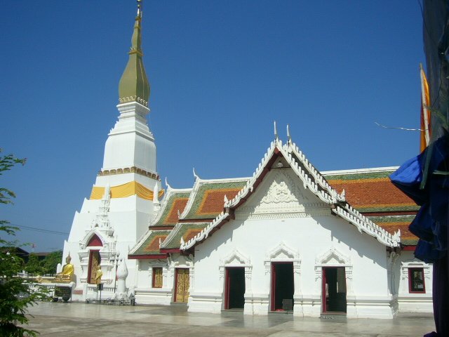 จังหวัด
Sakon Nakhon Province
Sakon Nakhon is a province in upper northeastern Thailand covering 9,606 square kilometres, home to Nong Han — the largest natural lake in all of northeastern Thailand. The province had a registered population of approximately 1.14 million in 2023.
สำรวจ → จังหวัด
Nakhon Phanom Province
Nakhon Phanom, meaning 'city of mountains', is a province in upper northeastern Thailand situated along the west bank of the Mekong River, directly opposite the Laotian town of Thakhek. Covering 5,513 square kilometres with a population of around 710,000, it is known for its scenic riverside setting backed by the Phu Phan mountain ranges.
สำรวจ →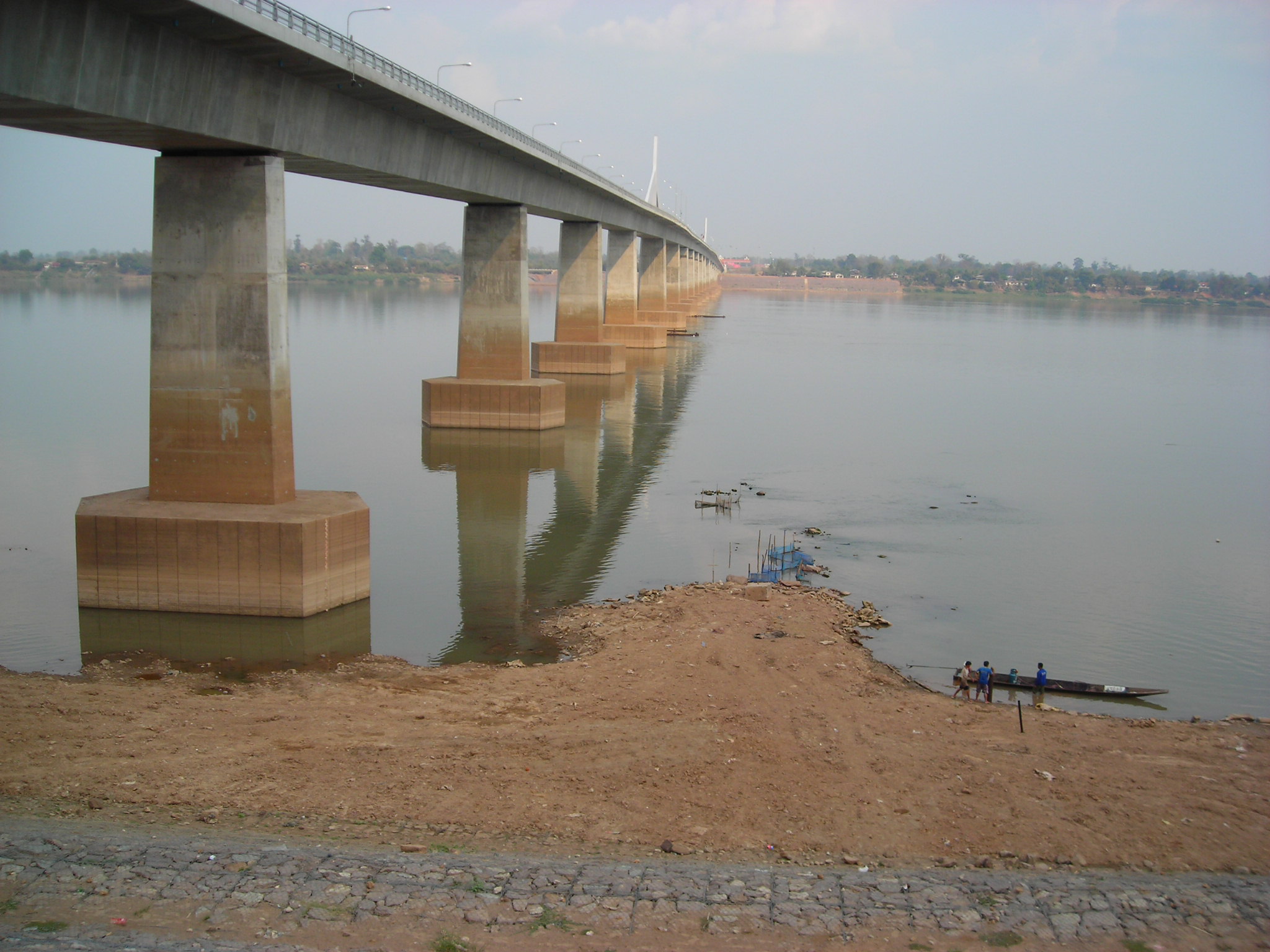 จังหวัด
Mukdahan Province
Mukdahan is a province in upper northeastern Thailand on the Mekong River, connected to Savannakhet province in Laos by the Second Thai-Lao Friendship Bridge opened in 2006. Elevated to provincial status in 1982, it is home to eight distinct ethnic communities including Phu Thai, Thai Yo, and Thai Saek peoples.
สำรวจ →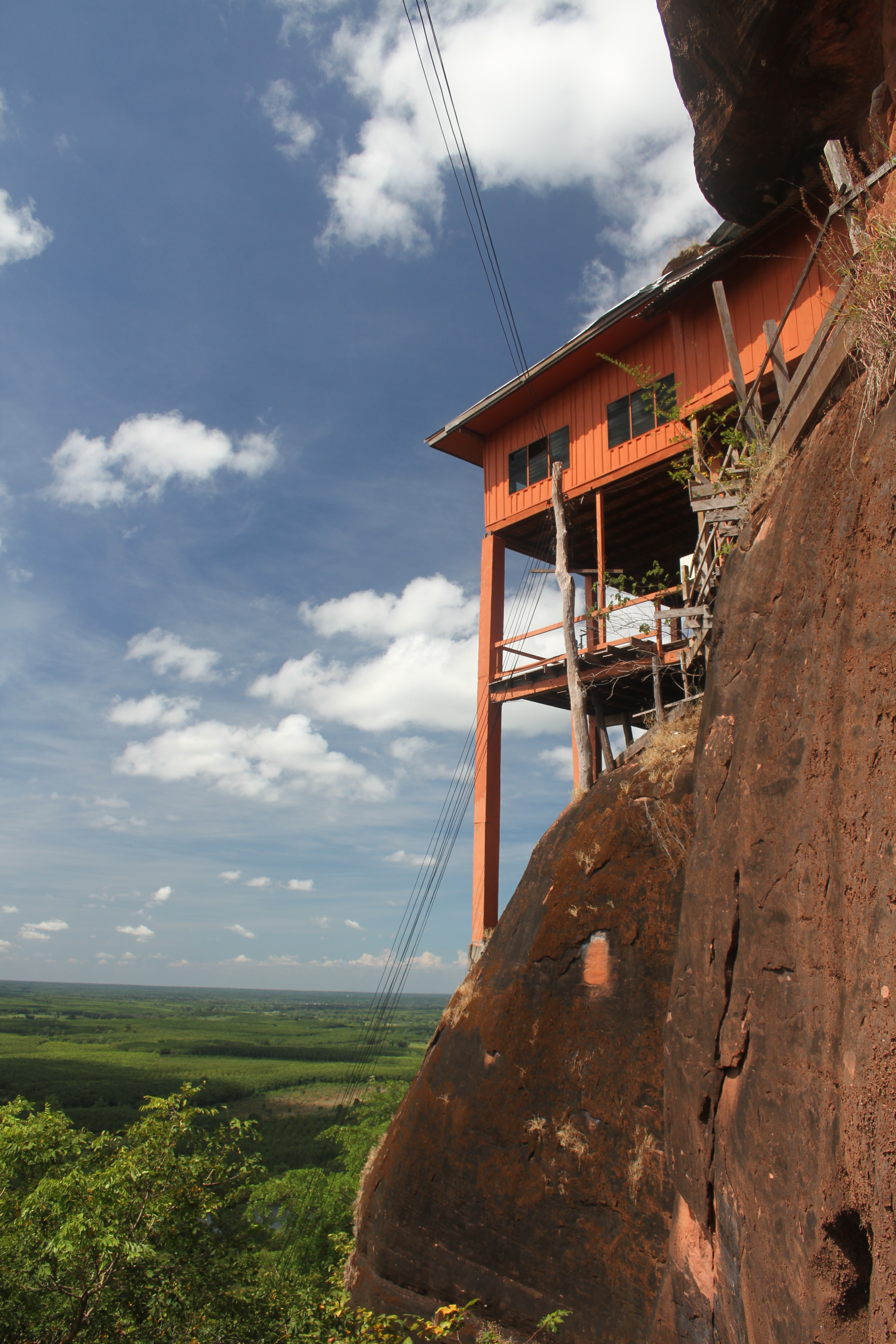 จังหวัด
Bueng Kan Province
Bueng Kan is Thailand's 76th and newest province, carved out of the eastern districts of Nong Khai on 23 March 2011, situated in the northeastern corner of the country along the Mekong River border with Laos. Covering 4,305 square kilometres with a population of approximately 385,000, it is named after its central district, Mueang Bueng Kan.
สำรวจ → จังหวัด
Chumphon
Chumphon is a southern province of Thailand situated on the Isthmus of Kra, where the Gulf of Thailand meets the beginning of the Malay Peninsula. With a 222-kilometre coastline and 44 offshore islands, it is often called the 'gateway to the south'.
สำรวจ → เกาะ
เกาะKo Phangan
Ko Pha-ngan is an island in the Gulf of Thailand, 15 kilometres north of Ko Samui in Surat Thani Province, covering approximately 168 square kilometres of forested mountains and white-sand beaches. It is internationally famous as the venue of the monthly Full Moon Party at Hat Rin beach.
สำรวจ → จังหวัด
Nakhon Si Thammarat
Nakhon Si Thammarat is one of the largest and most historically significant provinces in southern Thailand, situated on the east coast of the Malay Peninsula about 610 kilometres south of Bangkok. The province was a centre of the ancient Tambralinga kingdom and later the Nakhon Si Thammarat Kingdom, one of the most powerful polities in the peninsula.
สำรวจ → จังหวัด
Phatthalung
Phatthalung is one of only two landlocked provinces in southern Thailand, bordered by Nakhon Si Thammarat, Songkhla, Satun and Trang, and covering 3,424 square kilometres of hills and wetlands. It is regarded as the birthplace of Nang Talung shadow-puppet theatre and the Nora dance, two of southern Thailand's most important performing arts.
สำรวจ → จังหวัด
Songkhla
Songkhla is a province on the eastern side of the Malay Peninsula, bordering Malaysia's Kedah and Perlis states to the south, and home to Songkhla Lake — the largest natural lake in Thailand at roughly 1,040 square kilometres. The province is the most populous in the deep south with an estimated population of over 1.4 million.
สำรวจ → เมือง
เมืองHat Yai
Hat Yai is the largest city in southern Thailand and the principal commercial hub of the deep south, situated in Hat Yai District of Songkhla Province approximately 40 kilometres from the Malaysian border. Although Songkhla is the provincial capital, Hat Yai is considerably larger and functions as the region's dominant centre for trade, transport and services.
สำรวจ → จังหวัด
Pattani
Pattani is a coastal province on the Gulf of Thailand in the far south of Thailand, historically the centre of the Patani Malay Sultanate and today one of four predominantly Muslim provinces in the country. Its 170-kilometre coastline, fishing villages and historic mosques reflect a distinctive Malay-Muslim cultural identity.
สำรวจ → จังหวัด
Yala
Yala is the southernmost and one of two landlocked provinces in southern Thailand, bordered by Songkhla, Pattani and Narathiwat and sharing a southern frontier with Malaysia's Kedah and Perak states. Approximately 72 percent of its population are Malay-speaking Muslims, giving the province a strong cultural affinity with the Malay world.
สำรวจ → จังหวัด
Narathiwat
Narathiwat is the easternmost province of southern Thailand, bordering Malaysia's Kelantan and Perak states to the south and fronting the Gulf of Thailand to the east with the Bang Nara River as its principal waterway. About 82 percent of its population of approximately 819,000 are Muslim, reflecting the province's deep Malay cultural heritage.
สำรวจ → จังหวัด
Ranong
Ranong is Thailand's least populous province, situated on the narrow Kra Isthmus where the country is only 44 kilometres wide, bordering Myanmar's Kawthaung District across the Pak Chan River. The province lies on the Andaman Sea coast and, together with Trat on the opposite coast, is one of the wettest places in Thailand, receiving over 4,500 mm of rainfall per year.
สำรวจ → เกาะ
เกาะKo Phayam
Ko Phayam is a small island in the Andaman Sea off the coast of Ranong Province, protected within Mu Ko Phayam National Park, which was established in 2003. The car-free island is known for its cashew and coconut plantations, sandy beaches, and relaxed atmosphere that contrasts sharply with more developed Thai resort islands.
สำรวจ → จังหวัด
Phang Nga
Phang Nga is a province in southern Thailand on the Andaman Sea coast, renowned for its dramatic limestone karst towers rising from Phang Nga Bay and its offshore island groups including the Similan and Surin islands. The province takes its name from an ancient Malay term meaning 'jungle', reflecting its forested and mountainous interior.
สำรวจ → เมือง
เมืองKhao Lak
Khao Lak is a coastal resort area in Takua Pa District of Phang Nga Province, located approximately 60 kilometres north of Phuket along the Andaman Sea. The name literally means 'main mountain', referring to a peak historically used by ancient mariners as a landmark to navigate into the harbour at Thap Lamu.
สำรวจ → เกาะ
เกาะKo Yao Noi
Ko Yao Noi, meaning 'little long island', is the smaller but more visited of the two main islands in the Ko Yao Archipelago, situated in the middle of Phang Nga Bay between Phuket and Krabi. In 2002 it received the World Legacy Award for Destination Stewardship from Conservation International and National Geographic Traveler for its community-based eco-tourism homestay programmes.
สำรวจ → เกาะ
เกาะKo Yao Yai
Ko Yao Yai, meaning 'big long island', is the larger of the two main islands in the Ko Yao Archipelago in Phang Nga Bay, covering a total archipelago area of 147 square kilometres. Together with Ko Yao Noi to the north, it forms the Ko Yao District of Phang Nga Province.
สำรวจ → เกาะ
เกาะKo Lanta
Ko Lanta Yai is an island in the Andaman Sea off the west coast of Krabi Province, measuring approximately 25 kilometres in length and 6 kilometres in width, with an area of about 81 square kilometres. The island and its surrounding waters form part of Mu Ko Lanta National Park, designated in 1990 as Thailand's 62nd national park.
สำรวจ → จังหวัด
Trang
Trang is a province on the western coast of the Malay Peninsula in southern Thailand, facing the Strait of Malacca, with a coastline of approximately 199 kilometres and numerous offshore islands. The province is historically notable as the first place in Thailand where rubber trees were planted, introduced from British Malaya in 1899 by Governor Phraya Ratsadanupradit Mahison Phakdi.
สำรวจ → เกาะ
เกาะKo Muk
Ko Muk, meaning 'Pearl Island' in Thai, is a small island of approximately 7 square kilometres in Trang Province's Andaman Sea coastline, and the most visited of the Trang island chain. The island is renowned for Tham Morakot (Emerald Cave), where visitors swim through an 80-metre pitch-dark limestone tunnel to emerge in a hidden lagoon open to the sky.
สำรวจ → เกาะ
เกาะKo Kradan
Ko Kradan is an island in Trang Province, southern Thailand, described by the Tourism Authority of Thailand as one of the most beautiful islands in the province, famed for its white sand beaches and transparent water through which the coral reef is clearly visible. In 2023 it was ranked as the best beach in the world by TripAdvisor's Travellers' Choice Awards.
สำรวจ → จังหวัด
Satun
Satun is a province in the far south of Thailand on the Andaman Sea, sharing a southern border with the Malaysian state of Perlis and featuring Ko Tarutao Marine National Park, one of Southeast Asia's most ecologically important marine protected areas. The province has a Muslim majority population of approximately 324,000, making it one of Thailand's four Muslim-majority provinces.
สำรวจ → เกาะ
เกาะKo Lipe
Ko Lipe is a small island in the Adang-Rawi Archipelago of the Strait of Malacca in Satun Province, close to the Malaysian border, and is Thailand's southernmost inhabited island. Its name is derived from the Malay 'Pulau Nipis' meaning 'thin island', and the island falls within the boundaries of Tarutao National Marine Park.
สำรวจ → เกาะ
เกาะKo Bulon Leh
Ko Bulon Leh is a small island of approximately 3 square kilometres in Satun Province, lying about 22 kilometres from Pak Bara Pier in Langu District near the edge of the Tarutao National Marine Park. The island has remained largely free of commercial development, with local families operating nearly all accommodation and transport services.
สำรวจ →